How the Hani Rice Terraces Work: Forests, Water Channels and Villages on Honghe's Slopes

The Hani rice terraces work as a single linked system in which the forest, the water channels, the village and the flooded paddy fields each do a job the other three depend on, and the whole arrangement sits inside one watershed on the southern slopes of Ailao Mountain in Honghe prefecture, Yunnan. Nothing in that sentence is decoration: the forest catches the rain, the channels move it downhill at a controlled pace, the village draws drinking water and returns nutrients, and the terraces hold the water long enough for one crop of rice and a second life as a fish and duck pond. That is the whole of how the Hani rice terraces work in five clauses. Break any link and the water arrives too fast, too dirty, or not at all.
Hani rice terraces are usually introduced as a landscape, and that framing undersells them. Understanding how the Hani rice terraces work starts with treating them as human-designed travel infrastructure rather than scenery: applied hydrology, refined over roughly 1,300 years of continuous farming. Folk memory traces the first terraces to the Tang dynasty, and the Sloping Paddy Fields of Honghe were inscribed as a UNESCO World Heritage cultural landscape in 2013, in recognition of a farming system rather than a view. A visitor standing on a viewing platform at Duoyishu in the first week of December sees the same four elements a farmer in Azheke village manages every day, only flattened into one frame. This guide explains the mechanism, then walks through what you can actually observe on the ground.
UNESCO's inscription language describes the property as an exceptional example of a living cultural landscape in which forest, water system, village and terraces function as one managed continuum. The Food and Agriculture Organization of the United Nations, which recognised the same system as a Globally Important Agricultural Heritage System, has characterised the rice-fish-duck arrangement as one of the oldest continuously operating integrated farming systems documented anywhere. It helps to hold one number in mind before the detail. The Honghe Hani Rice Terraces landscape covers about 16,603 hectares, of which the core area is 4,732 hectares, and it runs across four counties inside Honghe prefecture: Yuanyang, Honghe, Jinping and Luchun. Around 82,000 households in the wider area still farm paddy on these slopes, and the system has been worked by Han, Yi, Miao, Yao, Dai and Zhuang families alongside the Hani for long enough that any account of how the Hani rice terraces work describes genuinely shared farming. That is why the clearest explanation of the system is plumbing rather than poetry.
The Four Layers of the System, Explained Simply
The quickest way to see how the Hani rice terraces work is to follow a raindrop from the ridge to the valley floor. The system moves that drop through four linked layers, and it begins in the forest above the village, soaking into leaf litter and soil before travelling downhill. The terraces have been cut into these slopes for roughly 1,300 years, and the oldest surviving sections have held their current wall lines for at least 700 of them. It crosses a hand-cut channel, passes through a village where some of it is diverted for drinking and washing, and then enters the top terrace. From there it moves down through more than three thousand individual paddies, each one slightly lower than the one above, before it drains into the valley stream. Nothing along that route is accidental.
Layer one: the sacred forest above the village
The forest that caps each ridge is called the village's water source forest, and in Hani villages it is treated as sacred rather than merely useful. Cutting in it is prohibited by customary rule, and the rule is enforced by the village itself. Calling this sacred is not superstition dressed as conservation: the upper woodland is the intake for the entire supply that makes the Hani rice terraces work. A mature broadleaf forest above a terraced slope intercepts rainfall, slows runoff, and releases water gradually through the dry months of January to April when the paddies are flooded but no rain is falling. Remove the canopy and the Hani rice terraces stop working within a few seasons.
The practical consequence for a visitor is that the highest belt of trees on any slope you look at in Yuanyang is infrastructure, not wilderness. Read it as the top of the arrangement, and the rest of how the Hani rice terraces work falls into place.
Layer two: channels that move water without eroding the hill
Water leaves the forest through a network of carved channels, known locally as ditch water, that run along the contours of the hill rather than straight down it. Running water across the slope instead of down it is the central trick of the whole design, and the clearest physical answer to the visitor question of why the water never runs straight down. It drops only gently, so it arrives at the paddies with enough energy to fill them and not enough to cut gullies. Where a channel crosses a gully or a road, it is carried over on a stone or timber flume. Where a village needs drinking water, a separate branch is taken off before the channel reaches the fields.
Because these channels feed every household and every field in turn, whoever controls the head of the channel controls the village. That is why Hani villages appoint a water manager, whose job is to walk the ditches, clear blockages, and decide the order in which fields are irrigated during the tight weeks at the start of the growing season. The role is one of the oldest continuing offices in the community, and it is the part of the design that visitors usually miss.
Layer three: the village in the middle
Hani villages occupy the middle belt of the slope, above the highest paddy and below the forest. The village sits in that band by design, because uphill there is clean water and firewood, while downhill there is rice and fish. Household wastewater and animal manure run down into the top fields and are consumed there as nutrients, which is why the terraces need so little bought-in fertiliser even after centuries of continuous cropping.
The village also supplies the labour. Maintaining a terraced slope is a permanent collective project, because walls fail, channels silt, and the whole surface of the hill must be repaired after a heavy rainy season. Without a settlement positioned close to the paddies, none of this would be viable at all.
Layer four: the paddies and the water they hold
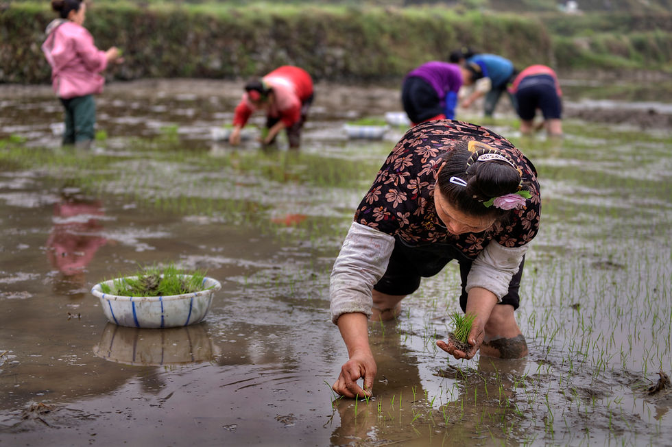
The terraces themselves are a storage device as much as a growing surface. Early in the season the paddies are flooded and planted; later, as the rice grows, water is held in circulating conditions rather than left stagnant, because moving water keeps temperature stable and reduces disease. Two ecologically valuable yields are obtained from the terraces: the terraces support a fish and duck farming system, with fish stocked into the flooded paddies to eat insects and weeds while their waste fertilises the rice.
The whole of how the Hani rice terraces work is summed up in a local saying that visitors hear often on the ground, in Chinese: the forest is the head, the water channels are the waist, the village is the heart, and the terraces are the tail. The saying survives because it is an accurate engineering diagram. A traveller trying to understand how the Hani rice terraces work can hold that image and be most of the way to the answer.
What You Can Actually See on the Ground
Reading about slope hydrology is abstract, while standing at the edge of a terrace at dawn is not. The following observations are the ones that most reliably turn a handsome landscape into an intelligible machine. Almost all of them are visible from public roads and walking tracks inside the core area, and none require special access or a guide.
Look at where the trees are, not just how many there are
From any of the main viewpoints, trace the hill from top to bottom, because the vertical order is the first thing to read when you want to see how the Hani rice terraces work. The upper belt of dark broadleaf forest, the scattered village houses in the middle, and the pale staircase of water below it are almost never arranged differently. Once you notice that every ridge in Yuanyang repeats the same three-band pattern, the logic becomes visible at a glance, and the arrangement no longer looks like a coincidence of terrain. A single hillside in the core zone can carry several thousand individual paddy fields, and the prefecture's protection rules extend to more than a hundred villages inside the listed area.
Watch a channel and see where it goes
Walk ten minutes along almost any village path and you will cross a channel, which is the quickest field demonstration of how the Hani rice terraces work. Stand still and follow its direction. The interesting detail is how rarely the water runs straight downhill. Contour channels curve around spurs and only drop at a shallow angle, which is the whole reason the soil has stayed in place for centuries. If you are there in April or May, you may also catch a farmer opening a small wooden gate or a clay plug to send water into one particular paddy, then shutting it again.
Note how a terrace wall is built
Terrace walls are not vertical. They lean slightly back into the slope so that water pressure pushes the wall against the hill rather than outwards. Most are faced in dry stone or packed earth with a grass or planted lip along the top edge; that vegetation holds the crown of the wall together through heavy rain. Try to imagine building one of these by hand, without machinery, across thousands of hectares, then keeping the walls watertight for a thousand years.
Spot the secondary life inside the water
Look into any flooded terrace in summer and you will see more than rice seedlings. Ducks work the shallow edges; small fish move in the deeper water; snails, insects and the occasional eel share the same pond. In some paddies you may notice a distinct channel or a stone marker along the edge; on the ground these are field markings, put in place to allow a single paddy to be treated as a separate farming unit when a household plants a local variety next to a commercial one.
Look for what has been replanted
Some slopes are noticeably bare in their upper belt, or carry shrubs rather than mature trees. Those are the places where the water source forest was cut during the twentieth century and has since been replanted. The replanting is one of the quieter stories of the slopes, and it is visible once you can tell regrowth from old growth.
These five observations cover most of what a curious traveller can verify without a guide. They are also the details that make the difference between photographing a staircase and actually understanding how the Hani rice terraces work.
The Hani Farming Calendar and the Water Year
Timing is the part of the system that surprises visitors most. The terraces are not most photogenic during the growing season; they are most photogenic in winter, when they are flooded and empty. Understanding the calendar explains both the beauty and the labour, and it is the single most useful planning information for anyone travelling to Honghe. The full cycle runs about eleven months from first flooding to final threshing, and the rice itself occupies roughly 150 to 180 days depending on variety and elevation band.
Month | What the terraces look like | What is happening in the system |
November to December | Fully flooded, mirror-flat; the classic reflected-sky photograph | Fields are submerged and resting; ditches are cleaned and walls repaired |
January to February | Flooded and often misty at dawn; ice possible on the highest terraces | No rain; the water in the paddies comes almost entirely from the forest |
March to April | Water is being drawn down; patches of soil begin to show | Ploughing, manuring and the first seedling beds; the tightest water weeks |
May to June | Green haze appears as seedlings are transplanted | Rice is planted; water levels are managed paddy by paddy |
July to September | Full green, then gold; heavy rain and frequent low cloud | Rice ripens; the wettest and least predictable weather of the year |
October | Harvested and drying; the staircase turns to straw and open earth | Rice is cut; ducks and fish are brought in before fields drain |
Why winter is the season to come
The famous photographs of the Honghe slopes are taken between November and March, when a flooded terrace behaves like a mirror, which is also the phase most visitors picture when they imagine how the Hani rice terraces work. Early morning is the better half of the day: fog often fills the valley before sunrise and then lifts, leaving water surfaces that reflect the sky in bands. The window is short: by mid-morning the reflection fades and the light flattens, and photographers working the core area are usually on a platform before first light and finished by nine.
Why the dry season is also the hard season
The reason the winter light looks so good is the same reason the dry season is dangerous for the farming system. From about January there is almost no rainfall, and the water sitting in those polished paddies has come down from the forest through the channels over a period of months. Every litre has been intercepted, stored and released by the canopy. That is when the sacred forest stops being a cultural detail and becomes visibly load-bearing, which is the practical core of the whole system. A degraded watershed shows up first in April as a half-empty paddy near the bottom of a slope.
The rice varieties and what they require
Honghe's altitude range is what makes the landscape work agriculturally: the slopes run from roughly 800 metres at the valley floor to over 2,000 metres at the ridge, creating distinct microclimates on a single hill, and that range is the reason there is never a single answer. Different paddies at different elevations are planted with different rice, and the traditional varieties are tall, long-season and tolerant of cool water. That variation explains why the slopes are farmed in such small units and why one household may hold paddies at several elevations.
One of these local varieties is the red rice that gives Honghe's most recognisable table dish, Honghe rice noodles, its colour and its faintly nutty taste. The noodles are eaten all over Yunnan, but the grain behind them grows on exactly these slopes. Understanding how the Hani rice terraces work therefore explains something you can taste, not just something you can photograph.
Water Rules, Cooperation and the Village Meeting
Moving one water supply through several hundred households in a fixed order cannot run on goodwill alone; it runs on explicit rules, and the rules are the social half of how the Hani rice terraces work. In Hani villages, water management is a formal community responsibility, and the allocation of ditch water is decided collectively rather than by whoever happens to own the highest field. This is the social layer that holds the physical system together, and it is the part of how the Hani rice terraces work that most travel writing skips entirely.
The water manager and the rotation
Each village appoints a water manager, who is responsible for the ditches and for directing water to fields in turn. In the driest weeks the rotation hardens into a strict timetable: families receive water only on assigned days and are fined by custom for taking more than their share or blocking a neighbour inlet. The fine is not the important part; the shared acceptance of the schedule is. Without it, the household at the top of the slope would simply keep everything.
Why the fields at the bottom still get water
The rotation exists because the terraces are hydraulically connected. Each paddy overflows into the one below it through a gap set at a fixed height, so a field that takes too much water does not keep it; it passes the excess down the chain. The spillway gap is the mechanism that makes cooperation cheaper than conflict, and it is the single detail that most convincingly explains the design. A farmer at the top who over-irrigates still loses the surplus, and the custom that assigns watering order simply formalises what the walls already enforce.
The village meeting as infrastructure
When a wall fails or a channel silts up badly, the repair is a communal work party rather than a contract. Villages meet, agree a schedule, and turn out together. This is one of the reasons the system has survived: maintenance sits in the calendar and is shared across households rather than left to individual owners who may lack labour or money. In practical terms, the terraces are maintained by the same institution that manages the water.
What changed in the twentieth century
The system has not been static. During the twentieth century, forest was cleared from some upper slopes, and there was a period when the traditional balance between watershed and field was under real pressure. In response, large areas were reforested, and village rules protecting water source forest were strengthened rather than relaxed. The 2013 World Heritage inscription formalised protections rebuilders had already put back in place, and it brought outside scrutiny of how walls, channels and forest were being kept up, which is now part of the management routine. Farmers interviewed around that time described the listing mainly in terms of pressure to keep the slopes in production rather than let them be abandoned.
That tension explains what a visitor sees today: an ancient system simultaneously protected, farmed and partly dependent on outside interest to stay economically viable. Anyone curious at a social level should pay attention to the fact that the rules were never only about water. Under the prefecture's terrace protection regulations the customary system is formally recognised, and allocation is settled by an elected water manager who answers to the village meeting, and the rules also set out who may repair a wall, who pays for the repair, and what happens when a household misses its turn. In that sense the village meeting is the maintenance department of a public utility that has no engineers, no meters and no invoices, and it has been running on nothing but agreed custom for a length of time that most modern infrastructure would struggle to match.
Mushroom Houses, Villages and Where the Water Meets the Roof
The villages are where the plumbing turns into architecture, and where how the Hani rice terraces work becomes something you can walk through. A Hani house is usually described in tourist material as a mushroom house, and the name comes from the shape rather than a botanical resemblance: a square ground floor in rammed earth or brick, topped by a steep conical thatched roof whose eaves oversail the walls on every side. The roof projects roughly a metre past the wall line. That overhang is structural rather than decorative: the region receives intense seasonal rain, and eaves projecting well beyond the wall keep the earth fabric dry, which is the difference between a house lasting decades and one lasting a century.
Why the roof shape suits the slope
A conical roof sheds water fast and in every direction, which matters when a house stands on a narrow terrace ledge with limited flat ground around it. The roof also extends toward the downhill slope, throwing rainwater clear of the foundation so it never undercuts the platform beneath. Several villages inside the landscape have retained these buildings, and a few have kept their original layout long enough to be recognised as heritage settlements, which matters because a replaced roof is the smallest unit at which how the Hani rice terraces work can be lost.
The village as a working unit
Inside a Hani village, the layout usually follows the water, so a walk downhill through the lanes is the most compact way to watch how the Hani rice terraces work. The upper lanes carry drinking water diverted from the channel before it reaches the fields; the middle lanes handle household use; the lower edge is where water leaves, carrying nutrients into the top paddies. Granaries sit close to the houses or at the edge of the settlement, positioned so that stored grain stays dry and away from the damp of the terraces. Walking a village slowly, you can read the sequence of the whole system in a few hundred metres of lane, which is the easiest place to see the design at household scale, and it is why human-designed travel puts people in villages rather than only on platforms.
What visitors should not assume
It is easy to arrive expecting
It is easy to arrive expecting an untouched village and find, instead, a working community with motorbikes, satellite dishes and new concrete houses. Some travellers read that as loss. A more useful reading is that families who choose to stay and farm are what keeps the terraces from reverting to scrub, and better-roofed modern houses are part of that decision. The older mushroom houses survive where households have repaired them rather than replaced them.
This is where the experience side of a Hani visit sits. The villages are not exhibits; they are the middle layer of the watershed, and the people living in them are the reason the water rules exist at all. A mushroom house is also a working building rather than a museum piece: the ground floor holds animals, tools and stored grain, the upper floor holds the family and the smoke that keeps the timbers dry and the insects down. That vertical division is the same logic as the slope itself, packed into a single hearth.
The Best Places to Watch the Terraces
The Honghe landscape is large, and where you stand changes what you understand as well as what you photograph, so the ranking below is ordered by how much each platform reveals about how the Hani rice terraces work, not only by how impressive the view is. All of them sit in Yuanyang county unless noted otherwise, and all are reachable by road.
1. Duoyishu - the sunrise platform, and the classic four-layer view
Duoyishu is the most photographed spot in the landscape and the best single place to see how the Hani rice terraces work in one frame: forest on the ridge, village in the middle, terraces filling the bowl below. Arrive well before sunrise, because the valley fog that makes the reflections famous forms in darkness and burns off fast. A ticket is required at the main platforms.
2. Bada - the largest single staircase
Bada holds the widest span of continuous terraces in the core area, and there is arguably no better place to grasp how the Hani rice terraces work at scale: the paddy count runs into the thousands and plain description tends to understate it. It suits sunset rather than sunrise. Count the visible levels from the railing and you will see why no single household could manage such a slope alone.
3. Laohuzui, Tiger's Mouth - the steepest and most dramatic
Laohuzui carries the sharpest gradient and shows most clearly how contour channels hold a slope together, which is the single most legible piece of evidence for how the Hani rice terraces work. Because the drop is steep, the spillways between paddies stand out. Come at sunset.
4. Azheke village - the settlement that explains the middle layer
Azheke is a compact Hani village of traditional mushroom houses near Duoyishu, and the most useful single stop for learning how the Hani rice terraces work where village, water and field meet. Walk the lanes downhill and follow the water. Small guesthouses and family kitchens operate here, so it is among the easier places to spend a night inside the landscape rather than beside it.
5. Qingkou - the folklore village at the foot of the slopes
Qingkou sits below the main terraces as a demonstration village, with handicraft workshops and performances. It offers the most accessible introduction to Hani material culture and makes a reasonable first stop before climbing to the viewpoints.
6. Shengcun and the wider market towns
Shengcun is the main town in the core area, with guesthouses, restaurants and the market where farming families trade, and a market morning is often the clearest introduction to how the Hani rice terraces work as a livelihood. The morning market shows the terraces as an economy rather than a view: red rice, dried fish from the paddies, vegetables and tools for ditch repair. It is the kind of stop that human-designed travel builds in on purpose.
7. Honghe county and Saba terraces - the quieter side
The terraces continue north-east into Honghe county around Baohua and Saba, with far fewer visitors and much the same farming system, so it is the calmest place to study the system as a whole. To watch the water rules operating without a crowd of tripods, this is the place.
8. Jinping and Luchun - the southern terraces
The UNESCO area extends into Jinping and Luchun, the least visited parts of the landscape and the hardest to reach, which is precisely why they reward anyone chasing the system rather than a photograph. They reward travellers who bring time and a driver. Expect fewer viewpoints, longer drives and villages where nobody sells anything.
A practical note on tickets: the main viewpoints in Yuanyang fall under a combined ticket, while the villages and county roads that teach most about the farming system stay open. Platforms are busiest in December and January, and the connecting roads slow to a crawl in mist. Arriving by 06:30 in those months is the difference between a clear frame and a row of tripods, while the same platform at 07:30 in July may hold fewer than a dozen people.
Getting There, When to Go and What It Costs
The Honghe terraces lie in southern Yunnan, roughly 300 kilometres south of Kunming, and getting there is easier than the remote reputation suggests, which matters when deciding how much time to give how the Hani rice terraces work. Most travellers base themselves in Xinjie town in Yuanyang county, which has guesthouses at a range of prices and sits about forty minutes by road from the main viewpoints, close enough to reach a sunrise platform and still be back for breakfast. The practical decision is whether to self-drive, hire a car with a driver or join a small group.
How to get to the terraces
By road from Kunming takes about six hours to Xinjie, depending on traffic and weather, and that drive is short enough that distance should never be the reason to skip the slopes on which how the Hani rice terraces work depends. The most comfortable option is a private car with a local driver, which also solves the early-morning problem: sunrise platforms demand a departure around four or five, when no public transport runs. A train to Jianshui or Mengzi followed by a road transfer is an alternative for travellers coming from the east, and it is the route most people use when combining Honghe with a wider Yunnan itinerary.
When to go
Water-filled terraces usually appear from November to March, with the best light in December and January, and those weeks are when the system is easiest to explain to a first-time visitor. Green terraces are at their fullest from July to September. Harvest, in October, is the least photographed and arguably the most interesting month for anyone who cares how the system actually functions, since the paddies drain and the cycle visibly closes. Spring, from March to April, brings the highest water pressure and the hardest farming.
What a visit costs
Budget travellers in dormitory beds eating at market stalls generally spend around 300 to 500 yuan a day including transport. Mid-range guesthouses in Xinjie run roughly 200 to 400 yuan a night, and a car with a driver for a full day of viewpoints typically costs several hundred yuan more, which is the price of the flexibility any serious look at the slopes requires. Private guided trips cost considerably more and usually include interpretation of the farming system, which is where the real value sits. As a working figure, a five-day private arrangement with a driver-guide, mid-range guesthouses and entry tickets commonly lands between 3,000 and 5,000 yuan per person, excluding flights to Kunming. A combined viewpoint ticket stays valid for several days, so a two-night stay costs no more in entry fees than a rushed one-night visit.
What to expect from the walking
The viewpoints are short walks from car parks, but the villages are built on slopes and the paths between terraces are uneven, steep and often wet, so the examination is best done in shoes with grip. Footwear with grip matters more than appearance, and trekking poles help on the stone stairs, because the grade is relentless. Daytime temperatures in winter are mild, but dawn at two thousand metres is genuinely cold, and the temperature difference between a sunny platform and a shaded village lane is large.
Anyone planning a first visit should also budget time away from the platforms. The terraces are easiest to appreciate after you have stood in a village lane with water running past your feet and understood where it came from and where it is going.
The Farming Knowledge Behind the Landscape
Engineering supplies only half of the story. The other half is knowledge held by farming families, passed on without writing and applied paddy by paddy every season. That knowledge is why a slope can be farmed for thirteen centuries without exhausting its soil, and it is the part of the system that most rewards patient attention. The FAO designation of the rice-fish-duck arrangement as a Globally Important Agricultural Heritage System rests on exactly that continuity: the same fields, the same water order and the same varieties, kept in production without a fallow century.
Reading water and soil by eye
Experienced growers judge water depth, soil temperature and rice health by looking rather than measuring, which is the knowledge that keeps the whole system running without instruments. They know which paddies run cold from where the channel enters, which hold water thanks to the clay beneath, and which need manure because the previous crop drew too heavily. This is knowledge accumulated over generations on one specific slope, and it does not transfer easily to another hill.
Seed selection and the local varieties
Traditional varieties on these slopes are tall, long-season and tolerant of cool irrigation water, which is what a high-altitude terrace demands, and that mix is itself an outcome of centuries of selection shaped by how the Hani rice terraces work. Families keep their own seed and select each year for the paddies that performed best. The red rice behind Honghe rice noodles is one expression of that selection, surviving because it is both agronomically suited and commercially wanted.
Fish, ducks and the fertility cycle
Stocking fish and ducks into flooded paddies is not a novelty added for tourists; it is part of the fertility cycle at the centre of how the Hani rice terraces work. Birds and fish eat insects, snails and weeds while their droppings feed the rice, so the household also harvests protein from the water that grows the grain. When fields drain before harvest, the fish and ducks are brought in, which is why October in a Hani village smells of both cut straw and cooking.
Medicinal plants, dye plants and the forest margin
The belt where forest meets farmland is used for more than water, and the forest margin is the layer of the system that visitors almost never see. Families gather medicinal herbs, bamboo shoots, wild vegetables, dye plants and firewood there, which is why the village ban on clearing the upper forest is genuinely supported rather than simply obeyed. The forest feeds the household as well as the ditch.
Put together, this is the knowledge half of the system and the reason the landscape is legible. Seed saving is part of that knowledge too: families keep their own lines of glutinous and red rice, select the fullest heads at harvest and store them separately for the next spring, generation after generation. That habit is why the slopes still grow varieties that never entered a commercial catalogue. The visible staircase is the output of a knowledge system that decides water depth, variety, nutrient and timing on a surface where error margins stay tiny, and human-designed travel exists to put travellers in front of that knowledge rather than above it. The knowledge is mostly tacit: it lives in the hands of growers who have farmed one slope for decades, and it is passed on by working beside someone rather than by reading. That is why a guide who grew up in the valley can explain in ten minutes what a plaque cannot, and why that difference is worth paying for.
Staying Inside the Landscape
Most visitors see the terraces from a vehicle, a good way to cover viewpoints and a poor way to grasp how the Hani rice terraces work. Spending at least one night inside a village changes what the trip is about. It also puts money directly into households whose decision to keep farming is what holds how the Hani rice terraces work in place.
Village guesthouses and what they offer
Family guesthouses in Azheke and several surrounding villages rent simple rooms, often in or beside a traditional house, at roughly 150 to 350 yuan a night. Expect shared bathrooms in the cheaper places, wood-fired heating in some, and consistently excellent home cooking. Booking is easiest through Chinese platforms, and English is limited outside the larger properties. Total room capacity inside the villages remains small, numbering in the low hundreds across the core area, which is precisely why the landscape never feels crowded even when the platforms fill at sunrise.
Meals worth planning around
The food is one of the strongest reasons to stay, and a meal of red rice and paddy fish is a direct taste of the system. Honghe rice noodles made with local red rice are the regional staple and are usually eaten at breakfast. Families also serve cured pork, wild vegetables from the forest margin, bamboo shoots, paddy fish and duck, and glutinous rice steamed in bamboo. In the mushroom season, from roughly June to September, wild mushrooms from the surrounding hills dominate the table. Eating with a family is also the easiest way to understand the farming year, because the meal changes with it: fresh bamboo in spring, river snails and paddy fish through the wet months, cured meat once the fields drain. Meals are usually served early, and a shared table is the normal arrangement rather than an exception.
Walking between villages
Several marked and unmarked paths connect villages across the terraces, taking two to five hours depending on the route, and every one of them is a walk through how the Hani rice terraces work rather than past it. Walking them is the best way to inspect the channels close up, since a road crosses a slope while a footpath follows it, and that is also the best way to feel the design underfoot. Hire a local guide for the longer routes; paths fork frequently and mist can close in quickly. Start early, carry water and a rain layer, and tell someone at the guesthouse where you are going. The best walks are between Duoyishu, Azheke and Shengcun, which can be linked across a single morning on foot.
Etiquette in a working village
Ask before photographing people, and expect refusals, because the villages are workplaces rather than sets built to explain how the Hani rice terraces work. Do not enter terraces, walk on paddy walls, or cross a field to reach a viewpoint; the walls are load-bearing and can be damaged by foot traffic. Never disturb water gates or channels, even to look closer. Ask before entering a house or courtyard, and remember that the village lanes are working lanes rather than visitor paths.
A well-designed small-group trip usually allows at least two nights in the area, one guided village walk and a market morning; that is the shape human-designed travel takes on these slopes. That is enough time to see the system operate rather than just photograph its surface.
How Kiki Holidays Approaches a Honghe Trip
Kiki Holidays is a China-based travel designer that builds private itineraries rather than selling fixed departures, and the Honghe terraces suit that model because the landscape rewards time and punishes haste. Human-designed travel in practice means starting from what a particular traveller wants to understand, then arranging the days around that rather than allocating seats on a coach.
Designing around the light, not the map
Because water-filled terraces only look their best for a short window each morning, a sensible Honghe itinerary is built backwards from sunrise, which follows directly from how the Hani rice terraces work. That usually means two or three nights in the core area rather than one, and a driver who knows which platform to reach on which morning. It also means accepting that fog sometimes wins, and building one spare morning into the plan. The same logic applies to how the Hani rice terraces work as a subject: it rewards a third night more than a fourth viewpoint. Yunnan's own tourism reporting points the same way, showing that visitors who stay five nights or more in a region report markedly higher satisfaction than those passing through in two, and Honghe is a clear case of that effect.
Including the farming, not just the viewpoints
The most consistent feedback from travellers who go deeper into Honghe is that the viewpoints turned out to be the least interesting part of the trip. Village walks, a market morning, a home kitchen and a conversation with a family about water rotation all give more lasting value. Human-designed travel here means deliberately reserving days that contain no famous view at all.
Practical standards
Trips are arranged with licensed drivers and vehicles, local guides where interpretation matters, and transparent pricing that separates accommodation, transport and guiding so travellers can see what they are paying for. Timing is set around the light and the farming calendar rather than around fixed departure dates, and the days are spaced so that a slow morning at a viewpoint is not traded away for a longer drive. Kiki Holidays operates as a compliant, no-shopping-tours business, so nothing in the itinerary is built around commission stops, which is the practical difference between a designed trip and a cheap group tour in this part of Yunnan.
Combining Honghe with the rest of Yunnan
The terraces sit naturally on a southern loop that includes Jianshui's old town and Confucian temple, the tin town of Gejiu, and the markets and rainforest further south toward the border, so how the Hani rice terraces work can be set against a broader reading of Yunnan. Read against a wider itinerary, the Honghe stop is where a trip shifts register from sightseeing to observation. Travellers who want to understand how the Hani rice terraces work are usually the same travellers who want three days there rather than one, and the itinerary should be built to allow it.
Anyone weighing up a visit can start from the season, then the number of nights, then the level of interpretation required. In this landscape those three decisions matter far more than the choice of hotel, and they determine how much of the design you actually leave with. The practical details are simple: bring cash, because small village shops may not take cards; expect little English outside the larger properties; and treat an invitation into a home as exactly that, rather than as a service that was purchased. A slower plan also spreads spending across more households instead of concentrating it at one gate, which is why the villages that keep their schools open are usually the ones that see fewer coaches. Visitors who stay two or three nights, eat in family kitchens and hire a local guide tend to leave with a fuller picture and to leave more behind them.
Frequently Asked Questions
Q1. What are the Hani rice terraces and where can I see them?
They form a terraced paddy landscape, and the short answer to how the Hani rice terraces work is that four layers share one watershed: forest, channel, village and flooded paddy. They lie on the southern flank of Ailao Mountain in Honghe prefecture, southern Yunnan, about 300 kilometres from Kunming, and they are the clearest surviving example of the system. The designated area runs to roughly 16,603 hectares across Yuanyang, Honghe, Jinping and Luchun counties. Main viewpoints such as Duoyishu, Bada and Laohuzui sit in Yuanyang county.
Q2. What is the forest-village-terrace system?
It is a linked watershed arrangement, and forest-village-terrace is the short name for it. Reading the four layers as one machine is the fastest route to understanding the design. Broadleaf woodland on the ridge captures rain, contour channels carry it downhill at a controlled pace, settlements take drinking water and return nutrients, and flooded paddies hold the remainder before releasing it to the valley stream. Each layer depends on the other three.
Q3. Why is the forest above a Hani village treated as sacred?
Because it is the intake for the entire water supply. Without that upper woodland the channels would run dry by February, which is why the forest leads every explanation of the system. Customary village rules forbid cutting in the upper woodland, and the ban is enforced locally. The canopy intercepts rainfall during the wet months and releases it slowly through the rainless weeks from January to April, when the fields are under water but no rain is falling.
Q4. When is the best time to see water-filled terraces?
Usually from November to March, with the clearest reflections in December and January. Those are also the weeks when the water in the paddies has travelled furthest, a detail winter visitors rarely notice. Early morning is best, because valley fog lifts shortly after sunrise and the water surface mirrors the sky. By mid-morning the effect fades and the light turns flat.
Q5. Do the terraces stay flooded all year?
No. They are deliberately submerged through the dry season, then drawn down in spring for ploughing and seedling beds, which is a farming decision rather than a scenic one and a central part of how the Hani rice terraces work. From roughly May the fields are planted and held at managed depths, and by October they drain for harvest. Winter flooding is a farming practice, not a scenic arrangement.
Q6. How does water get to the fields at the bottom of a slope?
Through contour channels that run across the hill rather than straight down it, and through spillway gaps set at a fixed height in each paddy wall. Once a terrace is full, surplus water overflows into the field below. A village water manager walks the ditches and assigns watering turns during the driest weeks.
Q7. Are there fish and ducks in the paddies?
Yes, and they are part of the fertility cycle rather than a tourist display. Nutrient recycling through the water is one of the least visible parts of the cycle. Fish and ducks are stocked into flooded fields, where they eat insects, snails and weeds while their droppings feed the rice, one closed loop inside how the Hani rice terraces work. The household then harvests protein from the same water that grows the grain.
Q8. What is a Hani mushroom house?
A dwelling with a square ground floor in rammed earth or brick and a steep conical thatched roof. The roof is a small but indispensable part of the design, because a leaking house on a wet slope is not liveable. The cap oversails the walls on all four sides. The deep eaves keep the earth walls dry during heavy seasonal rain. Examples survive in several villages inside the landscape, notably at Azheke.
Q9. How many days should I allow?
Two nights in the core area is the practical minimum if you want a sunrise, a sunset and a village walk, and about the least time in which how the Hani rice terraces work becomes legible. Three nights lets you add a market morning and a longer path between villages without rushing, and it is also the point at which the visit stops being a photography trip.
Q10. What does a trip to the terraces cost?
Budget travel with market meals and dormitory beds runs about 300 to 500 yuan a day including transport, and any guided interpretation costs extra and normally runs as a day rate. Mid-range guesthouses in Xinjie cost roughly 200 to 400 yuan a night, and a car with a driver for a full day of viewpoints adds several hundred yuan. Private guided trips cost more and include interpretation.
Q11. Do I need a ticket to visit the terraces?
A combined ticket covers the main viewpoints in Yuanyang county, though villages and channels stay free to walk. Whichever ticket you buy, the villages and channels that explain the system remain free to walk. County roads, villages and markets are open without one. Tickets are checked at the platforms themselves, so budget for it if you plan to visit more than one sunrise or sunset spot.
Q12. What should I avoid doing in the villages?
Do not walk on paddy walls, cross fields to reach a viewpoint, or touch water gates and channels, because the walls carry structural load and the gates control allocation. Ask before photographing people or entering a courtyard, and treat the lanes as working thoroughfares.
The reason the Honghe slopes hold attention longer than most scenic landscapes is that there is something to solve. That is exactly what human-designed travel is built to explain. Once you can point at the ridge and say what the trees are doing, then follow a channel to a village and a village to the top paddy, the view stops being decorative and becomes a machine you can read, and how the Hani rice terraces work stops being a question. A visitor who arrives understanding that will look at a flooded terrace in December and see stored rainfall, a maintained wall, and an old agreement about who waters when.
That is also the argument for slowing down. Three hundred kilometres from Kunming, on a slope farmed for thirteen centuries, the interesting material is not on the platform. It is in the lane where the ditch runs past a doorway, in the market where paddy fish and red rice change hands, and in the meeting where a village agrees to mend a wall before the rains come: three ordinary scenes that together explain how the Hani rice terraces work.
Sources and Fact-Check Trail
- UNESCO World Heritage Centre - Cultural Landscape of Honghe Hani Rice Terraces, inscribed 2013 (16,603 ha total, 4,732 ha core; Yuanyang, Honghe, Jinping, Luchun counties)
- UNESCO World Heritage Centre - Hani terraces property documentation on the forest, water channel, village and terrace continuum
- Yunnan Provincial People's Government - Honghe Hani Rice Terraces protection and management reporting
- Honghe Hani and Yi Autonomous Prefecture government - rice terrace protection regulations and village water management rules
- China Daily and Xinhua reporting on Hani terrace preservation and the sacred water source forest system
- Yuanyang county tourism authority - viewpoint access, ticket system and seasonal visitor guidance
- Food and Agriculture Organization of the United Nations - Globally Important Agricultural Heritage Systems documentation on rice-fish-duck integrated farming
- Field notes compiled from viewpoint visits, village walks and market observations in Yuanyang, Honghe, Jinping and Luchun counties


Comments